The navigation function is one of the modern smartphones and tablets most valuable features and services. It allows you to easily and quickly navigate places you’ve never been and don’t know. The most popular online navigation service is Google Maps. This is because this service is relatively fast and has many tools that allow you to get detailed information about your route and all the obstacles you may encounter. However, sometimes users are faced with the fact that they need to find a point halfway to their destination, and many do not understand how to do it in Google Maps.
Doing it in Google Maps will not be as easy as it may seem. The fact is that there is no unique tool that can show you a point halfway to your goal. This means that you have to use alternative methods. For example, manually calculate the distance and find the point, or use a third-party service with this capability. Let’s take a closer look at all your options and how they work.
Is there a special tool that allows you to find halfway in Google Maps
As noted above, if you want to find halfway on your route in Google Maps, it is impossible to do this directly from the app. At least you will be unable to find the exact point halfway through your route. However, you can view the entire route and roughly calculate halfway points.
This can be very useful if you are traveling long distances. For example, if you need to drive more than 5-6 hours, it’s a good idea to stop somewhere and rest or spend the night. I recommend that you look roughly at the general map of your route halfway and choose a suitable place.
You can use a third-party app if you need to know what’s halfway. In addition, Google Maps has a tool that allows you to track the exact distance between two points in a straight line. Using this tool, you can see half of this segment using a special measurement ruler, which will be displayed on your map. Let’s take a closer look at each method.
How to calculate the distance between two locations directly in Google Maps
Let’s start by figuring out how to measure the distance between two points on Google Maps. Note that this method will show you the distance between the two points. It can help you to determine the halfway point on a straight road. You can do this most conveniently in the PC version of Google Maps. To do this, you will need the following:
- Open Google Maps in any browser and find your starting point.
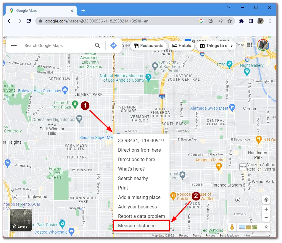
- Right-click on this point and select Measure Distance from the drop-down menu.
- After that, put the cursor on the final point and left-click. You will see a line between the two points and information about the distance.
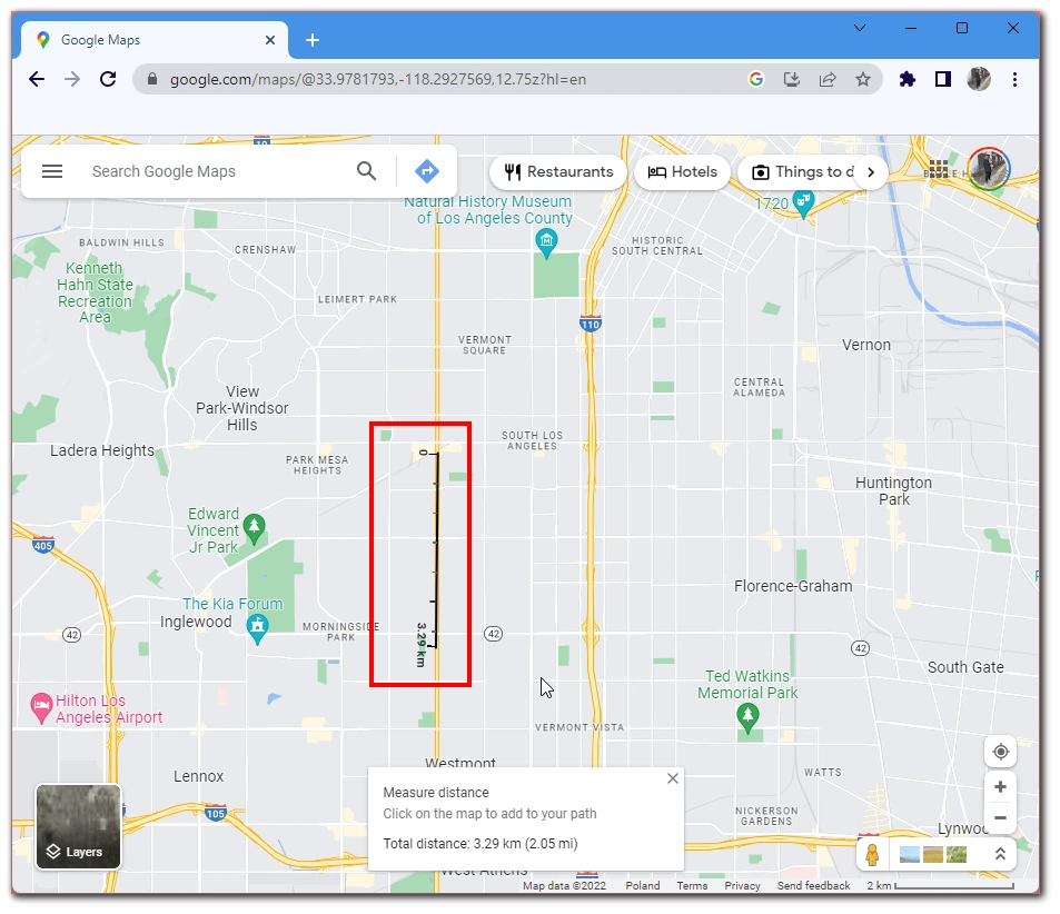
Note that the line between the two points will contain many divisions. You can count them and select the division in the middle of the line. It will be halfway in this case. Note, however, that this is not an exact way to measure the distance as this method does not take into account the terrain and counts the distance from a point to point directly using the map. So the actual distance may be more or less than the map shows you.
What Websites can be used to find the halfway point between two addresses
Another way that you can use to view a point in the middle of your route is to use a third-party service. I want to tell you about two services that I’ve tested so that you have an alternative if one of them doesn’t work for you for one reason or another. They are WhatsHalfway and TravelMath.
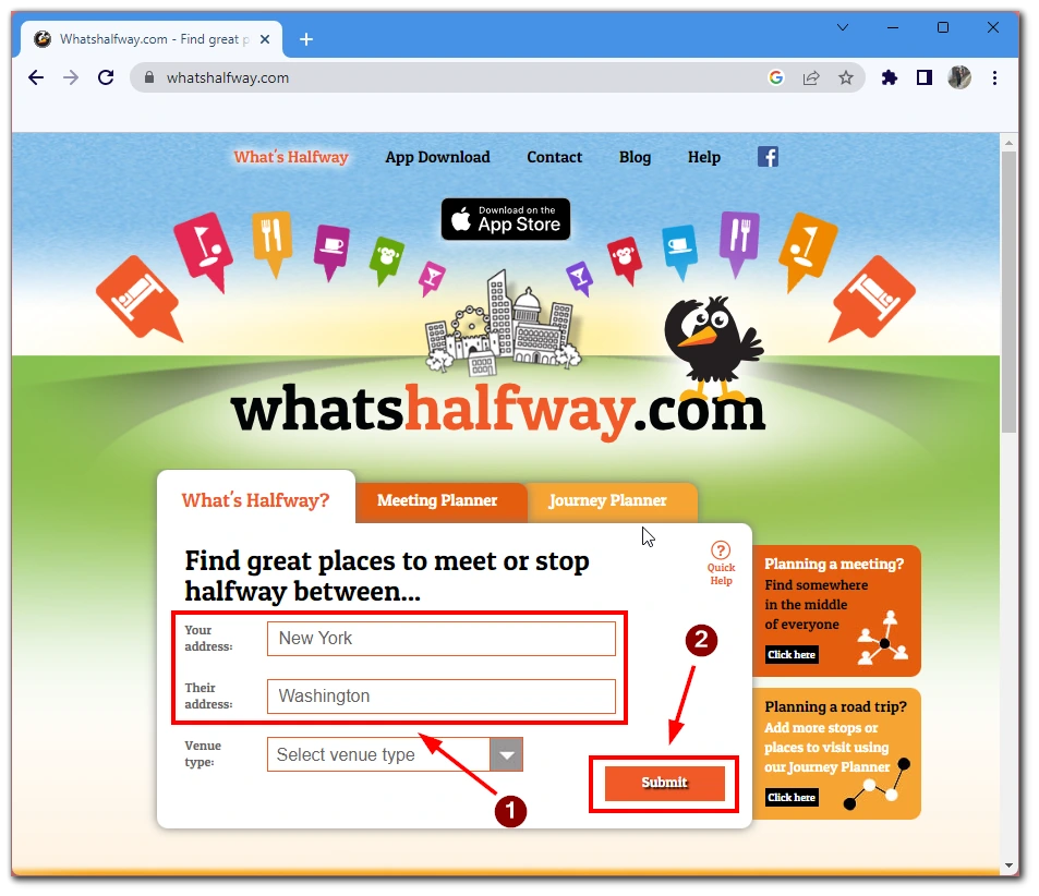
Let’s start with the more straightforward WhatsHalfway service. This service is specifically designed for viewing the point in the middle between two addresses. As simple as possible, you need to enter two addresses (start point and final point), then a map will appear in front of you where the service will highlight the point in the middle. Also, using a special button will take you to Google Maps, where you can view all the valuable places around the point on half of the route. Such as hotels, restaurants, or parking lots. It’s pretty convenient, accessible, and works all over the world.
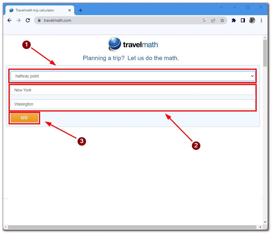
There’s also the TravelMath service. It allows you to get more information about your route. You’ll need to select Halfway in the all calculations column to start. After that, enter two addresses and start the search. You will see the city that lies in the middle between these two points. Also, if you swipe down a little bit, you will see the route and the exact point in the middle on Apple Maps. In addition, this service can provide other information about your route. Such as its length, the time it takes to get there, and even the cost of the gasoline you’ll spend on the route.

